River Modelling
Need for river modelling
Although the Environment Agency and Natural Resources Wales provide extensive flood mapping this tends to cover only the main rivers and excludes many smaller watercourses. In addition they sometimes say that their existing river models need updating or are not sufficiently accurate to assess the flood risk to a proposed new development. All this means that river modelling work is often required if an acceptable Flood Risk Assessment (FRA) or Flood Consequence Assessment (FCA) is to be produced.
FRA's (in England) and FCA's (in Wales) are required by the National Planning Policy Framework (NPPF) and Technical Advice Note 15 (TAN15) to accompany planning applications in areas liable to flood.
Flood modelling can have many uses including:
• To assess if a proposed development would be likely to suffer, or cause, flooding.
• As part of an FRA or FCA (usually incorporating the previous point).
• Environmental Impact Assessments
• Flood mapping
• Investigation of river flooding problems
• Design of flood alleviation schemes
• The assessment of the consequences of the failure of a reservoir or flood defences.
• Design of structures situated on or in river channels (bridges, culverts and weirs)
Our software
We undertake hydraulic river modelling using Flood Modeller Pro (formerly ISIS), TUFLOW or HEC-RAS software. Much of the river modelling work we undertake is in connection with proposed new developments, see TUFLOW river modelling, Ystradgynlais and River Pelenna modelling study.
Approaches to flood modelling
In broad terms there are three approaches to flood modelling, these are 1-Dimensional (1D) river modelling, 2-Dimensional (2D) flood modelling and a combination of the two approaches (linked 1D - 2D flood modelling).
The use of 1D and 2D, in terms of river and flood modelling, refers to the flow of water. So for 1D modelling the water flows in one dimension along the
watercourse while in 2D flood modelling the water can flow in any direction across the ground surface.
1D River Modelling
We can use Flood Modeller Pro, TUFLOW (ESTRY) or HEC-RAS software for the 1D modelling of watercourses including the associated structures such as culverts, bridges and weirs.
A river modelling study will often use flow hydrographs produced by a Flood Estimation Handbook (FEH) hydrological assessment of the watercourse. Further input data required includes cross-sections and levels along the watercourse channel. These are often obtained by carrying out a topographical survey and if required, we can plan, organise and supervise this as part of our service.
LiDAR data
In addition to topographical surveys, a further source of ground level information is LiDAR data. LiDAR stands for Light Detection and Ranging. The data is produced by an aircraft mounted LASER which is directed onto the ground and the reflected light is analysed by computer to produce a rectangular grid of x, y and z ground surface co-ordinates. LiDAR data is typically available in either DTM (Digital Terrain Model) or DSM (Digital Surface Model) forms. DTM excludes trees, vegetation and buildings while these are included within DSM data.
2D Flood Modelling
An alternative to 1D River Modelling in some circumstances can be 2D Flood Modelling. While the former requires the watercourse channel to be represented by a series of cross-sections, the latter models water flow over a representation of the ground surface with x, y and z co-ordinates.
We use Flood Modeller Pro 2D or TUFLOW software, usually together with LiDAR data, to carry out 2D flood modelling work. As with 1D models, the technique is often used in conjunction with flow hydrographs derived from an FEH hydrological study.
Comparison of 1D and 2D flood modelling
2D flood modelling is especially useful in representing flows across a river flood plain but the software can also be used to model flows in river channels. The programs, however, have limitations in this respect due to the spacing of the LiDAR data grid. 2D flood modelling may also not be satisfactory when representing structures within the river channel such as bridges, weirs and sluices.
1D river modelling software on the other hand is particularly suitable for modelling structures within river channels. Conversely although the 1D modelling software can represent water storage within flood plains this can be complex and time consuming, so 2D software is more suitable in that respect.
Linked 1D - 2D flood modelling
A linked 1D - 2D flood model allows each program to do what it does best to arrive at the most effective modelling solution. Using this approach the 1D model represents the river channel while the 2D model represents the flood plain. The two models operate in conjunction with each other with the 1D model passing flood water to the 2D model and visa versa as the storm develops.
Linked 1D - 2D river models are to a large extent the industry standard method of river modelling and are used extensively by the Environment Agency and Natural Resources Wales to produce their flood mapping.
Further Information
Flood modelling work is site specific so please
contact us for further information including a free no obligation quotation.
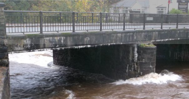
Photograph: Claypon Bridge, Ystradgynlais. Note that there are flood walls along both banks of the river which extend some distance upstream and downstream of the bridge. There are also flood gates at either end of the bridge which can be closed to complete the flood defences when there is a danger of high river levels.